





About GeoVex - Daily Geography Challenge
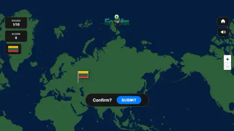
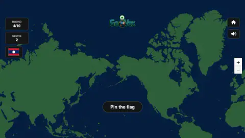
Most flag quizzes give you four names and ask you to pick one. GeoVex takes the names away, and the borders too. You get a flag, a dark world map with green land and blue sea, and a pin. Where you put the pin is your answer, and the game measures it in kilometres.
That changes what being wrong means. In a multiple-choice quiz, Lithuania and Kazakhstan are equally wrong answers for the Lithuanian flag. Here, a pin in the right corner of Europe still earns something, and a pin on the wrong continent earns nothing. You are rewarded for knowing roughly where a country is, even when you cannot find its exact outline.
We played GeoVex on a desktop with a mouse and got through three of the ten rounds before our session ended in the middle of the fourth. Our score was 2. Everything below comes from those rounds and our screenshots of them, and what we did not reach is listed near the end.
The game is credited to Danillo Abreu. It was listed in March 2026, last updated in August.
Kilometres, not right answers
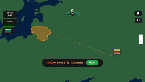
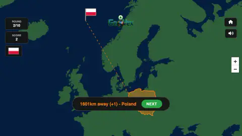
The result bar after each round reads like a ruler: distance, points, then the country's name. Our first pin, dropped in western Russia, came back as "1290km away (+1) - Lithuania". Our second, in the sea off Norway, came back as "1601km away (+1) - Poland".
Those two misses were more than 300 kilometres apart, and they paid exactly the same: one point each. The points come in steps, not on a sliding scale.
The game's listing gives the steps. A pin inside the country is worth 10 points. Closer misses pay 5 or 3, and anything within 2,000 kilometres pays the single point we got twice. Farther than that pays nothing.
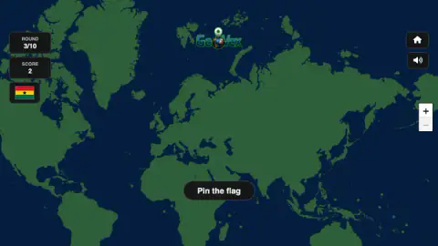
Our third round shows the cliff. We put Ghana's flag on the north-west coast of Africa, far north of the Gulf of Guinea, and the score stayed at 2.
So the useful habit is not "find the exact border". It is "never be more than 2,000 kilometres out". A pin in the right region always beats a bold guess on the wrong side of a continent, and on a borderless map the region is often all you can be sure of.
A map with nothing written on it
Every screen we saw showed the same plain map: green land, dark blue sea, coastlines, and not a single border or name. The listing says that is what Hard mode looks like, and that Easy mode adds both. Our session went straight into this version, and we did not see a menu that let us switch.
Without borders, landlocked countries are the hardest. You can find Ghana by its coast on the Gulf of Guinea, but Laos, our fourth flag, has no coast at all. It sits between larger neighbours, and the only way in is to remember what surrounds it.
The map is also drawn the way most online maps are: in a Mercator-style projection, the system the Flemish mapmaker Gerardus Mercator published in 1569. It keeps shapes recognisable but stretches everything far from the equator. On such a map Greenland looks about as big as Africa, while Africa is really around 14 times larger.
That matters for scoring, because the game measures your miss in real kilometres, not in screen distance. In northern Europe, a gap that looks wide on screen can be a short distance on the ground. Near the equator, the same gap on screen covers far more ground. A pin that looks "nearly there" in West Africa can be farther out than one that looks way off in the Baltic.
Three flags, one palette
Two of our four flags shared the same three colours. Lithuania's flag is horizontal stripes of yellow, green and red, first adopted in 1918. Ghana's is horizontal stripes of red, gold and green with a black star in the middle, adopted at independence in 1957.
Ghana's colours are the Pan-African colours. They come from the flag of Ethiopia, and Ghana's was the second African flag to use them. The black star stands for the freedom and unity of Africa. Many later African flags borrowed the same red, gold and green, so in GeoVex those three colours point you towards Africa far more often than towards the Baltic.
The star and the order of the stripes are what separate the two flags. Lithuania has yellow on top and no emblem; Ghana has red on top and the star. When a red, gold and green flag appears, look at those two things before you start dragging the map.
The fourth flag we saw, Laos, was red, blue and red with a white disc in the centre.
What we did not see
We did not finish a day's ten rounds, so we never saw the final score screen. The listing describes a Daily Challenge with a streak and a way to share your score; we saw the rounds counted out of ten but no streak or share button. We did not see Easy mode, and we did not land a pin inside a country, so the top scores of 10, 5 and 3 come from the listing, not from us. We only played on a computer; the listing says you can also swipe, pinch and tap on a phone.
Who it is for
GeoVex fits anyone who likes flags and maps and has a rough sense of where the continents are. With no clock and no lives to lose, it is calm enough for children, and the outlined answer after each round teaches something every time, even when you miss.
Complete beginners will find the borderless map hard going. If you cannot yet tell Poland from Norway on a blank map, start with a quiz that names the countries for you, and come back.
More flag and map games
World Flags Quiz turns it around: it names a country and shows four flags to choose from. World Flags: Color Puzzle asks you to paint a flag from memory. Flag Learn says it brings back the flags you miss until they stick, and Quiz Guess the Country is a quiz about country shapes. For more games for young players, browse the kids games.
Screenshots
Taken by opening the game ourselves and letting it run — not supplied by the publisher, and not the same picture every other site shows.
How to play GeoVex - Daily Geography Challenge
- A card opens each round with the round number and a flag. Press FIND COUNTRY to close it.
- Drag the map to pan and use the plus and minus buttons on the right to zoom. The flag you are looking for stays in a small box at the top left.
- Click the map where you think the country is. Your flag appears there on a pole.
- Press SUBMIT on the "Confirm?" bar to lock it in.
- Read the result, which gives the distance, the points and the country's name, then press NEXT.
What our rounds taught us:
- There is no clock. We spent well over a minute on one round, panning back and forth, and the game simply waited. Zoom in before you click; nothing is lost by checking.
- The map wraps around. Greenland and Alaska can sit on opposite edges of the same view. If you are hunting for East Asia and find the Americas instead, keep dragging the same way.
- Mind the "Pin the flag" label. It sits over the bottom middle of the map. In our fourth round we had South-East Asia near the bottom of the screen, and two clicks aimed at it landed on the label. No pin appeared. Drag your target up to the middle first.
- The sea counts. Our second pin landed in the ocean off Norway, and the game still measured it and paid a point.
Controls
| Click and drag the map | Pans the world map; it wraps around sideways |
|---|---|
| Plus and minus buttons, right edge | Zoom in and out (the game's listing adds the mouse wheel) |
| Click on the map | Drops your flag pin where you clicked |
| SUBMIT | Confirms the pin and shows how far you missed by |
| NEXT | Moves on to the next round |
| FIND COUNTRY | Closes the round card with the flag and returns you to the map |
Features
- Ten rounds, each one a national flag and a world map
- A map with no borders and no country names in the mode we played
- Answers measured in kilometres, with the real country outlined after every guess
- Partial points for near misses, so a wrong country can still score
- No clock on a round, so you can pan and zoom for as long as you need
- The target flag stays in the corner of the screen the whole round
- A map that wraps around, with the Americas on both sides of the Pacific
Game details
- Developer
- Danillo Abreu
- Release date
- March 2026
- Last updated
- August 10, 2026
- Added here
- December 2025
- Technology
- HTML5
- Platforms
- Browser (desktop)
- Saved progress
- Saving, when available, is managed by this game. Mava cannot confirm your level.
FAQ
How do you play GeoVex - Daily Geography Challenge?
Each round shows a national flag. You press FIND COUNTRY, drag the world map to the place you think it belongs, click to drop a pin and press SUBMIT. The game then shows how many kilometres you missed by and outlines the real country.
How is GeoVex scored?
You are scored on distance, not on right or wrong. The game's listing says a pin inside the country is worth 10 points, closer misses earn less, and anything farther than 2,000 kilometres earns nothing. In our run two misses more than 300 kilometres apart each scored exactly one point, and a pin in the wrong part of Africa scored zero.
Is there a time limit in GeoVex?
We saw none. There is no clock on screen, and we spent well over a minute panning around Asia in a single round without the game moving on. You can take your time, zoom in and check before you submit.
What is the difference between Easy and Hard mode in GeoVex?
The game's listing says Easy mode shows country names and borders, while Hard mode takes the borders away. The map we played had neither names nor borders, so it matched the listing's description of Hard. We did not see Easy mode ourselves.
Does GeoVex tell you the right answer?
Yes. After you submit, the map zooms in on the correct country, outlines it in orange and draws a dashed line to your pin. The country's name appears next to the distance, so every miss doubles as a short geography lesson.
Who made GeoVex?
The game is credited to Danillo Abreu. It was listed in March 2026 and updated in August 2026, and when we checked in October 2026.
Is GeoVex good for kids learning geography?
It suits children who already know roughly where the continents are. There is no clock and no penalty beyond fewer points, and every answer shows the real country. Without names or borders on the map it is hard for complete beginners, which is what the listing's Easy mode is meant for.